Click here to return to newsletter contents.
 |
In the summer of 2000, two IBM IntelliStations, equipped with the latest Geographic Information Systems (GIS) software including ArcView, ArcGIS, PCI Geomatica, and Idrisi 3.2, arrived in the basement of the Kelsey Museum of Archaeology. These two machines form the core of the Spatial Analysis/Geographic Information Systems Initiative project entitled "Spatial Analysis and the Archaeology of Early Civilizations in the Old World." This project was conceived and initiated by Susan Alcock, Associate Professor of Classical Studies and Adjunct Associate Curator for the Kelsey Museum, and Carla Sinopoli, Associate Professor of Anthropology and Associate Curator of the Museum of Anthropology. The project received a significant grant from the SA/GIS Initiative, funded by the Office of the Vice President of Research, the Rackham Graduate School, the Office of the Provost, and other participating units, with the goal of bringing together faculty and students interested in furthering the field of archaeology through Geographic Information Systems.
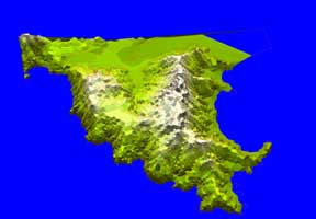
Geographic Information Systems are used in a large number of disciplines to link spatial information, such as maps, topography, or access to waterways, with other forms of data, such as population figures, rainfall, or street addresses. GIS is employed for many different goals, from determining sales figures for a retail chain to identifying the best farm land in the African hinterland based on soil runoff and rainfall. Archaeology uses GIS to link data such as finds, sites, and monuments with topography, land use, and findspots.
Geographic Information Systems provide incomparable tools for documenting, interpreting, and presenting spatial data. Archaeologists often devote a large amount of time to creating the maps that are used in GIS, as many geographic areas they study must be plotted into the platform. Once the data have been entered, however, it is possible to use GIS for many archaeological tasks both to study and to model the ways in which human beings have interacted with their environment.
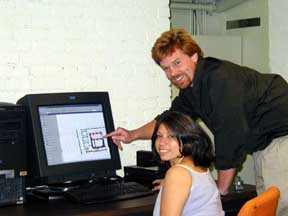
Although the use of GIS in archaeology is not new to the Kesley Museum or the projects operating under its aegis, the GIS initiative provides a unique opportunity for faculty, students, and researchers to learn and further incorporate GIS software into their work. The Spatial Analysis/GIS Initiative grant supplied the computers and now provides for their upkeep, offers opportunities for training in the software, and funds three graduate student researchers and hourly undergraduate research assistants each year. The project is designed to increase awareness of the potential inherent in GIS, as well as to increase interaction between students and faculty in Anthropology and Classical Archaeology. The initiative has been in operation for a year, and numerous projects have benefited from the equipment, training, and funding that the grant has provided.
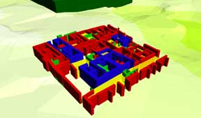
One project that has benefited is the ongoing excavation at Tel Kedesh. Under the direction of Sharon Herbert, Director of the Kelsey Museum, the project uses GIS to map the excavation within the topography of the area and plot in many of the archaeological finds. While some of the work is done in the field, much of the digitizing-which uses a large sensing board and a digitizing puck to "draw" lines in a computer-based map-and data analysis occur in the basement of the Kelsey. Another Kelsey project that uses GIS is the ongoing excavation of the Middle Cemetery at Abydos. Directed by Janet Richards, Kelsey Assistant Curator and Assistant Professor of Near Eastern Studies, this project uses GIS to record the topography and architecture found in excavation and survey. A third Kelsey project using GIS is the Pylos Regional Archaeological Project (PRAP) under the direction of Susan Alcock, who has used GIS extensively to document the location of finds during her survey work in southern Greece.
During the fall term of 2000, Rob Brubaker served as the GIS graduate student research assistant, creating numerous maps and documenting the sites found during Carla Sinopoli's survey in India at Vijayanagara. Rob frequently worked on the two machines in the basement and assisted Kelsey staff and graduate students in their GIS work.
Over the summer of 2001, I served as the GIS graduate student research assistant and worked on two different projects. First I finished digitizing maps of the Euboea that were begun by Elizabeth de Grummond, another graduate student in the Interdepartmental Program in Classical Art and Archaeology. The maps will be used to record sites found during the Southern Euboea Exploration Project (SEEP), an archaeological survey encompassing the southern part of the island, in which Lauren Talalay, the Kelsey's Associate Director, has long participated.
|
|
In addition to the work for SEEP, I also began a project to continue documenting the University of Michigan's excavations at Soknopaiou Nesos in Egypt. Although the site was excavated in 193132 and a preliminary publication came out in 1935, the work was never fully published. For this project, I digitized the topography and architecture from the excavation, linking these data with the artifact listings in the Kelsey Museum Registry Database as well as the records of ostraka found in the Advanced Papyrological Information System housed in the Harlan Hatcher Graduate Library. It is now possible to locate finds from Soknopaiou Nesos easily on a digital map of the site and to document the other finds associated with particular objects or excavation loci.
|
|
During fall term 2001, Patrick Livingood from the Department of Anthropology will focus on PRAP research during his tenure as the GIS graduate student research assistant. In the winter term, the research assistant will be Jennifer Gates, a graduate student in the Interdepartmental Program in Classical Art and Archaeology, who will pursue a number of Kelsey projects. The projects funded through the grant will continue to profit from the GIS equipment supplied by the SA/GIS initiative and the work of graduate and undergraduate students.
Drew Wilburn
Copyright © 2001 The Kelsey Museum of Archaeology, University of Michigan. All rights reserved.